WORKING AS BEAVER REALTORS

In 2017, Cascade Forest Conservancy began our beaver relocation journey with a big-picture approach. The first step was to conduct a spatial analysis across dozens of watersheds in southwest Washington to identify areas with environmental features that create suitable beaver habitat. The spatial analysis highlighted many streams, wetlands, and lakes that could support beavers, but there were many features that we would need to observe on the ground to ensure that was true. Were beavers already living there, or could these places be good candidates for relocation?


We began to survey beaver habitat in 2017.


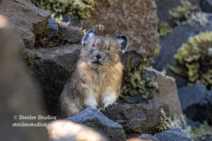
Our early surveys in 2017 and 2018 identified numerous active beaver sites, as well as approximately twelve sites that had once hosted beavers but were now empty, and these sites still had the features to support new colonies. Many were located in the headwaters of a watershed, in places hard for beavers to reach naturally. Since their near extripation in the late 1800s, beaver numbers have struggled to return anywhere close to what they once were. Trapping, in combination with other anthropogenic effects such as stream clearing, logging, and road creation, has led to beaver populations being more disconnected than ever. As a result, many ecosystems are still lacking these keystone species. 


A recent beaver release.


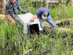
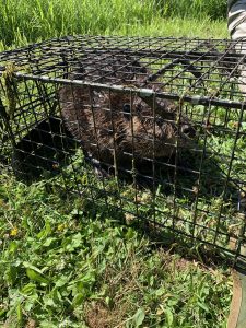
At first, our goal was to relocate beavers back into upper watersheds in the hopes that they would like the location we picked out for them, build a home, reproduce, and eventually spread downstream to reconnect with other populations. Over time, though, the focus of beaver management has shifted. These days, there’s more emphasis on helping beavers stay where they already are and working with landowners to minimize conflicts. But relocation still matters and is needed because there are still situations where beavers can’t stay put, and without relocation as an option, they would be lethally removed. Many of the sites where CFC has relocated beavers between 2020 and 2025 are still occupied today, which means we need more release sites, so it’s back to the National Forest to find more spots.


HOW WE’RE FINDING GOOD HOMES FOR BEAVERS


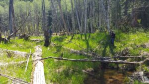
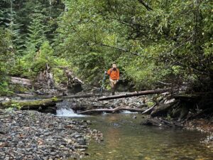
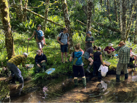
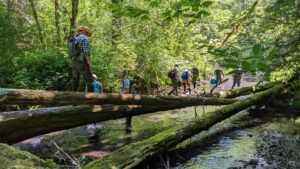
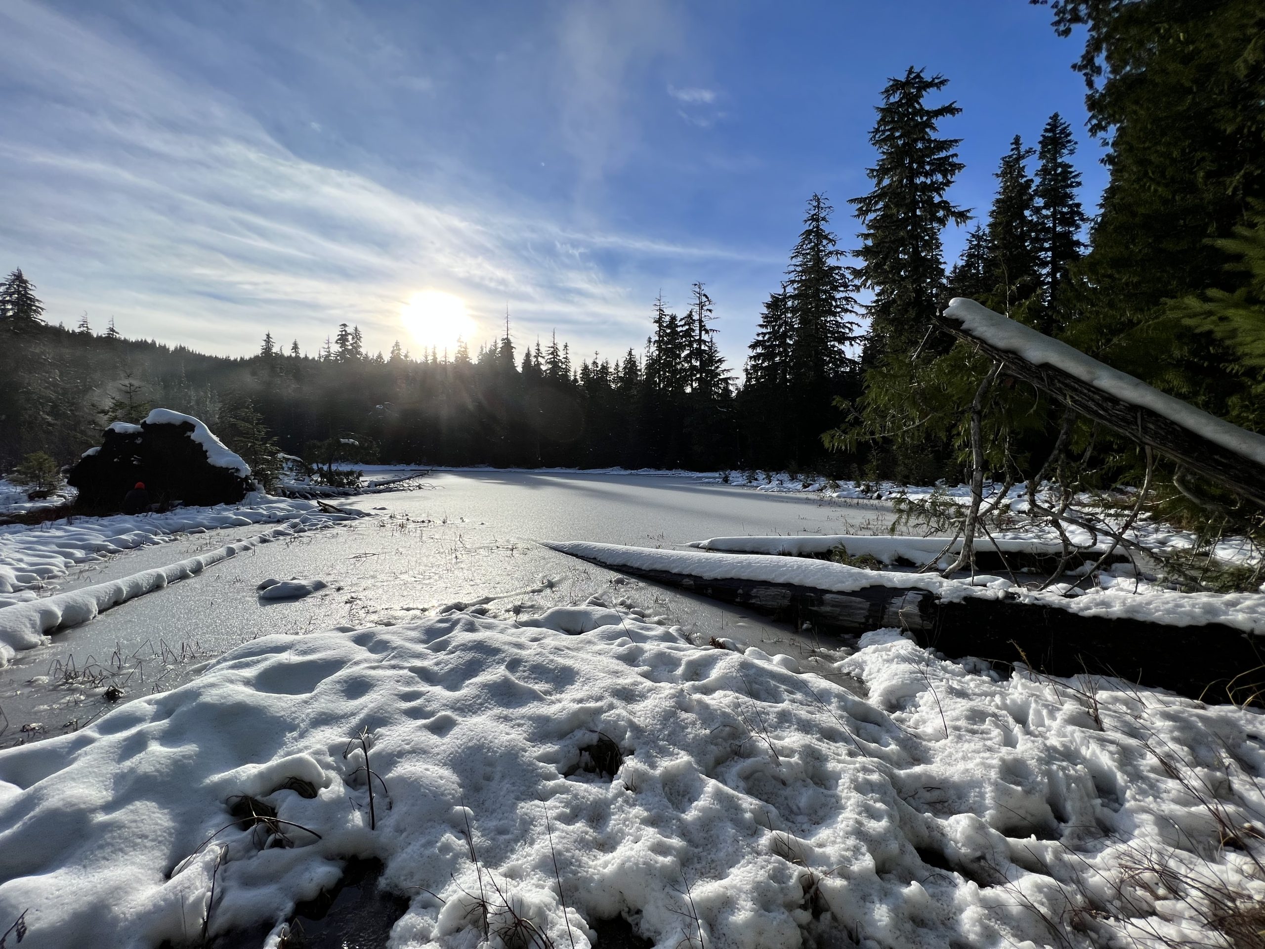
This summer and fall, we’ve been trekking through the north zone of the Gifford Pinchot National Forest (north of the Lewis River), surveying potential habitat. These locations were identified as “high potential” by a spatial model created by researcher Ben Dittbrenner, whose work informed our first analysis back in 2017. Since then, he and his team have refined the “beaver intrinsic potential” model and applied it across many states nationwide.

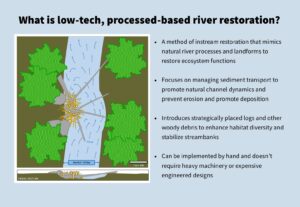
So what makes good beaver habitat anyway? And how do we decide if a site is relocation-ready? Luckily, we’ve got a scorecard that looks at what beavers need and what they prefer! 

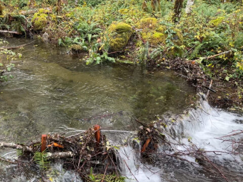
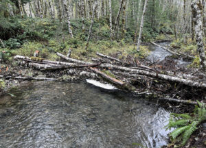
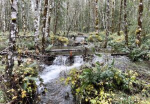
The number one requirement is obvious – water. But not just any water will do. Beavers need slow-moving streams, ponds, or lakes that have areas that are at least three feet deep so they can easily escape predators.

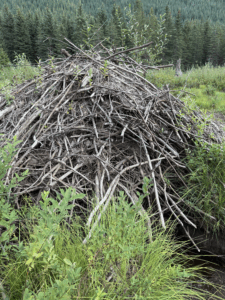
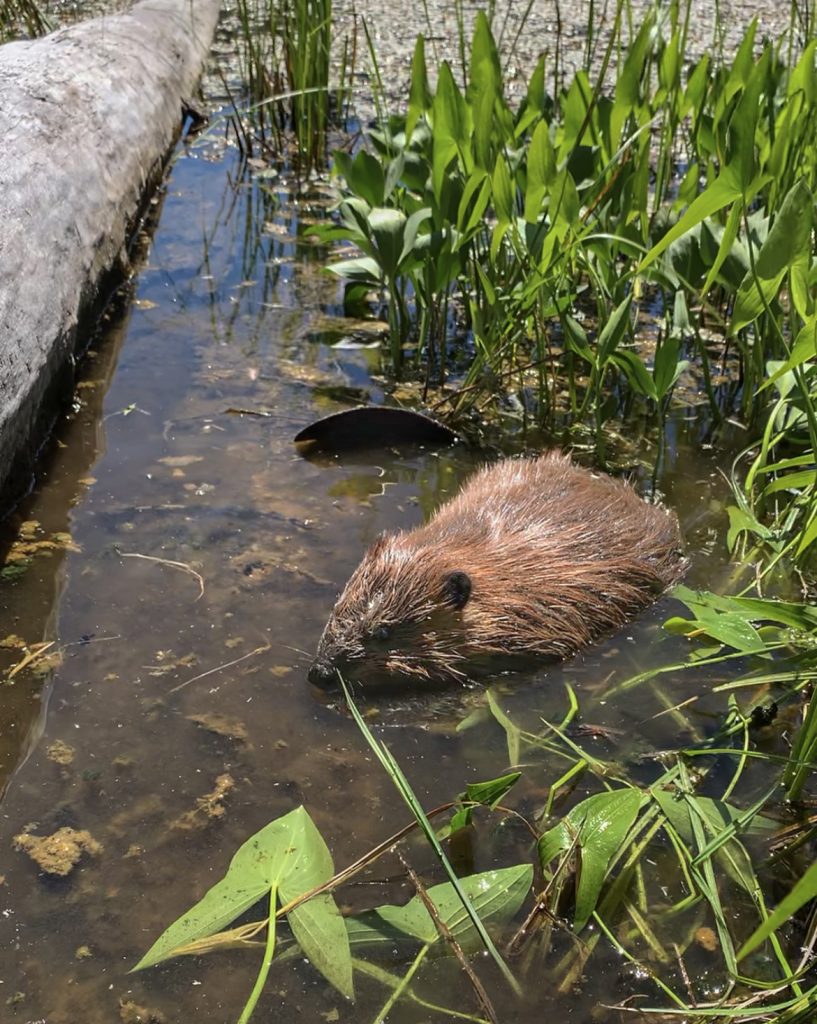
They also need building supplies for the dams and lodges they make. Not all beavers build dams, and not all beavers build lodges, but we want to make sure enough material is available in case they ever want to construct.  Beavers use both hardwoods and conifers for dam and lodge material, from small stems to large trees. When it comes to food, they are more particular. Willow, cottonwood, maple, and red alder are at the top of their menu in southwest Washington. They eat other herbaceous plants, but the cambium layer and leaves from these tree species are what they enjoy most. Sites with seemingly endless willow stems are basically a beaver buffet, but since deer and elk like the same plants, we also look at grazing pressure to make sure there’s enough food to go around.


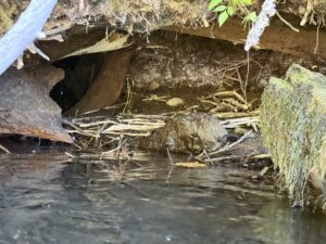
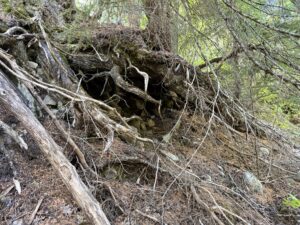
Another feature we look for is muddy streambanks. As mentioned before, not every beaver builds a lodge. Some prefer to make a den by burrowing into a stream bank, typically under a tree with a strong root system that helps keep the walls of their den nice and sturdy. They have relatively small front paws but have really long claws, so they can easily dig into finer sediments to burrow.

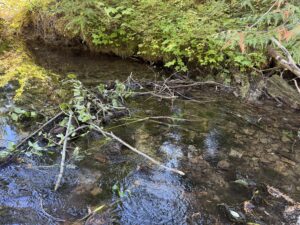
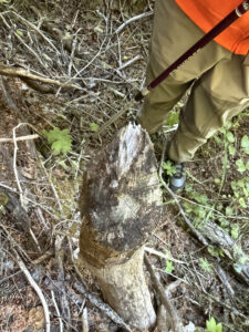
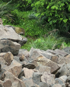
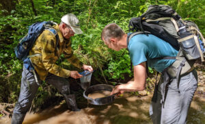
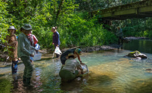
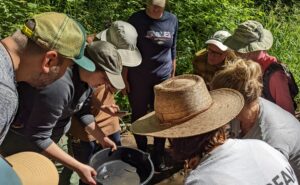
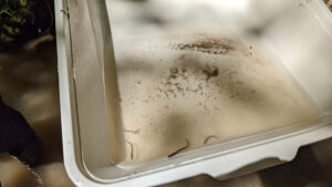
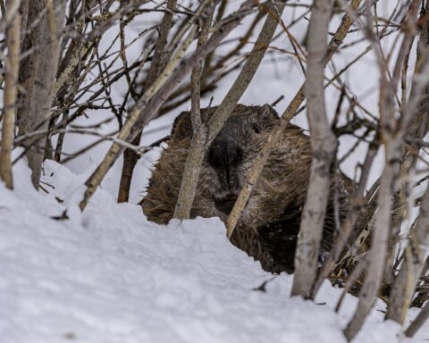
If we find all of the features the beavers are looking for, we need to ensure that there are no beavers currently living in the area for it to become a suitable relocation site. That means searching for signs like chewed sticks, food caches, lodges, dams, slides, or burrow entrances. The thing that solidifies current inhabitance is seeing scat. It breaks down quickly in water, so any scat that is present means beavers are very likely present. Chewed branches with green leaves still attached, freshly packed mud on a dam, or newly placed sticks on a lodge are other clear indicators. Dried-out woody materials tell a different story: beavers were here once, but not recently. Finding old evidence but no new evidence is a good sign. It means that the habitat has the ability to support beavers as long as all of the features mentioned above still exist. At the end of the survey, we calculate the score and determine if it ranks as suitable. 

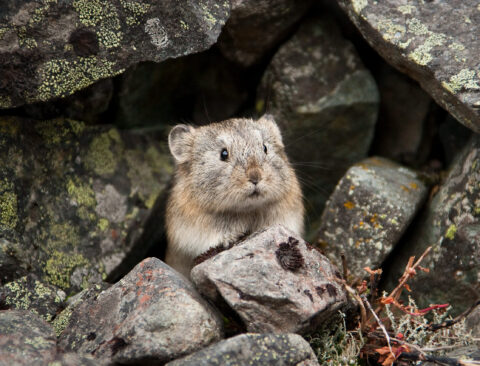
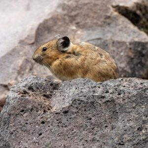
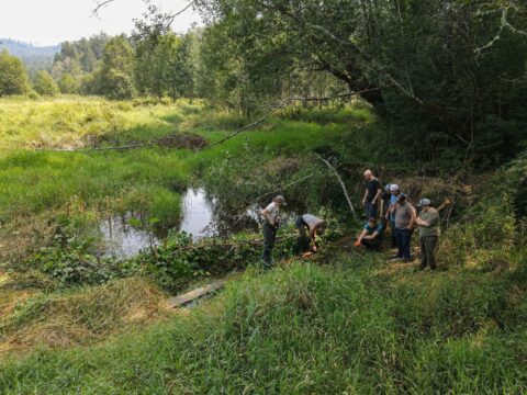
During these surveys, if we find new beaver evidence, we document it as well, so we can gain a better understanding of where beavers are currently living in SW Washington. Here is a selection of photos from our recent surveys. 
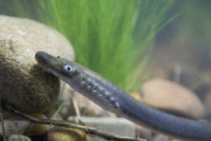
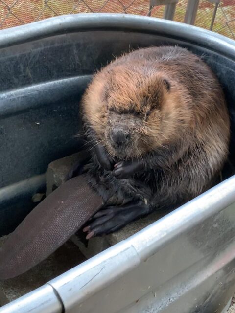
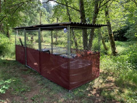
 

The start of a new dam – note the branches that have fresh green leaves still. We also found a lot of scat in the water in the area (tough to photograph, you just have to believe us!)


An older lodge that was currently out of the water, due to low summer-time flows. Beavers weren’t there in August, but there was enough other evidence to show that they go lower down into the system during the summer and will return once the rains start.


A somewhat unassuming hole in the stream bank, but upon closer inspection, we found dozens of old beaver chew sticks. Typically, this wouldn’t be exposed like this, but, like the previous site, lower summer flows have left it exposed.


A food cache found on the edge of the creek, hidden between a downed log and the streambank, and tucked under thick brush, this was the perfect out of the water spot to safely snack on willow.


A really old stump found amongst a lot of other older chew, indicating that beavers haven’t been at this site for a while. The abundance of willow, deep pools, fine sediments, and building materials along this low-gradient stream suggests that this would be a suitable relocation site.


SALMON ARE ALREADY BENEFITING FROM HABITAT ENHANCEMENT AT STUMP CREEK

After building instream structures in a dry creek bed this past summer, we headed back to Stump Creek in early November to see how the structures faired following the first bout of rain. As we headed down to the project site, we saw new channels that had formed, sediment had built up behind structures, and huge, deep pools had appeared. And in those huge pools – we saw huge coho salmon!


Tributaries of large rivers provide off-channel spawning habitat that is critical for the end of an adult salmon’s life and their juvenile offspring. Stump Creek is a tributary that flows into the South Fork Toutle River,  then into the Toutle River, Cowlitz River, Columbia River, and ultimately to the Pacific Ocean. That’s roughly 100 miles of waterways that these adult salmon travel to the ocean to grow big and then back to freshwater to spawn. Their journey from Pacific Ocean to Stump Creek is completely undammed, which is a rarity for anadromous fish to encounter. We are luckily seeing a movement to get more dams removed in the Pacific Northwest to restore access to more historical spawning grounds. 

The fish that make it to Stump Creek in the winter are met with a flowing stream and many reaches with spawning gravel. Once the fry hatch, they have plenty of water to swim and forage. By the time August roles around, the creek begins to dry up, leaving juvenile salmon stranded in small pools. During the past two summers we have been at Stump Creek,  we have found many dried out stream reaches that have piles of desiccated salmon fry. For this reason and it’s degraded state caused by anthropogenic and natural disturbances, Stump Creek has been a high priority for CFC and project partner, Lower Columbia Fish Enhancement Group.


A LOW-TECH, PROCESS-BASED APPROACH


Following the promising results from last year’s successful Pilot Phase CFC staff and volunteers spent three weekends in August and September working to complete Phase 1 of our restoration plan for Stump Creek. 

During the Pilot Phase and Phase 1, we worked to restore and improve this important fish habitat using a low-tech, process-based approach.


COMPLETING PHASE 1


Given the impacts we observed from the Pilot Phase, we were excited to add more wood to the stream. Over the course of three weekends, we installed a total of 32 structures along 1500 feet upstream of the Pilot Phase.

The first group of volunteers and staff arrived at the site in August and found a situation similar to what we had encountered the year before; dried-out stream reaches and fish stranded in tiny pools. We didn’t assume our first ten structures would completely fix Stump Creek, but the sight we encountered reiterated the huge need for more woody debris to help enhance and restore the system.


Our first team of volunteers worked hard in sweltering heat under hazy skies to construct the first 12 structures upstream from the Pilot Phase. These structure types ranged from:

  • beaver dam analogs – wood structures that most closely resemble a beaver dam, used on smaller, less powerful side channels 
  • channel process structures – larger wood structures made from numerous alder logs and slash that were built up on one side of the bank to promote the movement of water to the opposite side of the structure
  • channel spanning structures – larger beaver-esque structures made of numerous alder logs and slash that hold back sediment and create large pools
  • habitat cover structures – tops of the alder trees that are placed over the stream to provide cover for our aquatic friends 

The second weekend of work brought nicer weather and an even bigger group of volunteers! They managed to finish up the rest of the structures for a total of 32 structures. A few weekends later, a handful of volunteers and I went to put some finishing touches on the structures, set up wildlife cameras so we could watch the system change through time, and create a few extra habitat cover structures to try and help the dozens of fish that still remained in the tiny pools.


ENCOURAGING EARLY RESULTS


A final staff trip was conducted on November 10th. It had been raining for weeks, so it was time to see how the structures were holding up. We started by checking out the structures constructed during the 2022 Pilot Phase. As we’d observed earlier in the year, water in the Pilot Phase area was spreading all over the landscape and creating new channels. 

We headed west toward the Phase 1 structures. We first passed several of our larger channel process and channel-spanning structures. Not only were they all in place, they were directing water in the direction and manner we had designed them to when we planned the project! 


As we went further upstream, we came to our BDA section that we created on a side channel of Stump Creek. Our four BDAs that were working exactly as designed. We had created four cascading pools and spread the water outside of the previously confined channel. It was the perfect habitat for salmon!


So perfect in fact, that it was where we saw the first adult coho salmon of the day! We ended up seeing numerous other adult coho salmon utilizing the habitat enhancements our structures created. Some of them were swimming in the pools formed by the BDAs, others were preparing their redds (gravel bed to lay eggs) for spawning, and another was headed up stream to find find a location to spawn.

It was an incredibly rewarding sight. The lives of these coho would end here in Stump Creek, but their eggs are currently being incubated and will hatch in the next month or so. Once they do, our instream structures will be there to provide habitat for the new juvenile coho until they swim to the ocean. 


PROJECT UPDATE: INDEPENDENT VOLUNTEERS HAVE SPENT THE SUMMER PEAKING FOR PIKA

At the beginning of June, CFC hosted a virtual training session to teach volunteers how to survey for pika in the talus slope areas of the Gifford Pinchot National Forest. Pika survey efforts have been going on for years in the Columbia Gorge, Mt. Rainier, and other locations within the Cascades, but there’s a gap in pika population data in the Gifford Pinchot. 


Pika near Takh Takh Meadow by Susan Saul


Volunteers could go to sites where pika have previously been observed to conduct sitting surveys, or volunteers could send back reports if they happened to cross paths with a pika when out on a hike. Pika can be hard to spot as they are often well camouflaged by the rocks they inhabit, but wait long enough and they start to scurry around and make calls to the other pika nearby. So far this year, volunteers have conducted 30 sitting surveys and have had 34 opportunistic sightings.


Pika photographed at Goat Ridge Lookout by Jennifer Travers


These new pika sightings will allow us to have more sites to complete the sitting surveys next year. Most of our projects are not possible without the help of volunteers, and that is especially the case for the pika surveys. CFC sends a HUGE thank you to all the volunteers that have participated and are continuing to participate in the first year of these surveys! 


Pika photographed ay McClellan Viewpoint by Steider Studios


There’s still time to get involved! If you want to do a sitting survey, please contact amanda@cascadeforest.org so she can send you all the information you need to get started.


Pika photographed above Miller Creek by Mackenna Milosevich


If you’re ever out on a hike and come across a pika, feel free to share that information with us here.