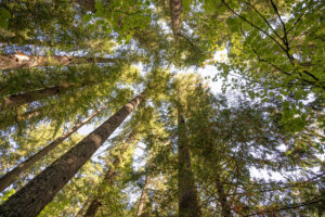
There are a lot of planning efforts both ongoing and new that will impact the future of our region’s forest ecosystems. All of these upcoming decisions will have a comment period or other opportunities to engage this summer and fall.
Several of these decisions are around the implications of climate change and how we protect and steward our forests through a changing climate.
Upcoming and ongoing planning efforts include:
Long-term management decision about Spirit Lake Outflow – planning has started to find a long-term solution to the tunnel at Spirit Lake as the original tunnel has reached its intended life span.
The National Old-Growth Amendment – planning has started on an amendment that would address how National Forests across the country manage for old-growth conditions.
The Amendment to the Northwest Forest Plan – planning has started on an amendment to update the Northwest Forest Plan, particularly around climate change, tribal inclusion, and wildfire.
The Little White Salmon Vegetation Management Project – planning has started in the Little White Salmon watershed with a focus on fire risk and resilience to climate change.
The Gifford Pinchot Forest Wide Thinning Project – planning has started on a Forest Wide effort to restore all plantation, monoculture forests, under 80 years old. This project would allow for treatment of plantations outside of the normal rotation of planning for particular watersheds.
CFC will be sure to let you know how and when to engage on each of these issues as the opportunities come up. Be sure you are subscribed to our email list so you don’t miss an opportunity to use your voice to speak up for a sustainable future!
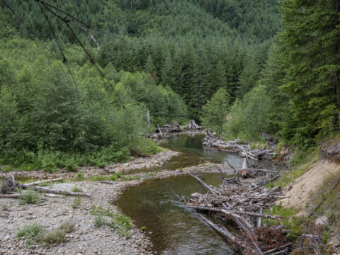
Vancouver, WA — on May 28, the US Forest Service released its final decision about the upcoming Yellowjacket timber sale. The decision came over the objections of concerned conservation groups, who say the agency’s plans do not adequately protect critical habitats and mature stands, and that the cumulative impacts of concentrated timber harvests on the area’s watersheds were not sufficiently considered by Forest Service planners. The Yellowjacket sale will occur on national forest lands in Lewis and Skamania counties east of Mount St. Helens in the Camp Creek-Cispus River and Yellowjacket Creek watersheds. The sale includes a total of 4,651 acres of timber harvest, in addition to various infrastructure and habitat improvement activities.
Molly Whitney, Executive Director of the Vancouver-based Cascade Forest Conservancy, said in an email to the group’s supporters, “[o]ur national forests are on the frontline of climate change. These places contain the vast majority of our region’s remaining old-growth and mature forests; a resource that belongs to all of us. The science is clear. Protecting old-growth and mature forests in the Pacific Northwest is critical to slowing climate change and creating resilience to climate impacts for our local communities, ecosystems, and wildlife. It is imperative that we work to protect these forests and enhance connectivity, but in many ways, the decision released by the Forest Service fails to do that.”
The Yellowjacket timber units are primarily composed of forests dominated by Douglas fir, western hemlock, and silver fir. These forests are located west of the Cascade crest, an area with abundant annual precipitation and a relatively low risk of wildfires.
Whitney says that one of the problems with the Yellowjacket sale is the intensity of the logging, pointing out the agency’s use of a controversial practice known as regeneration harvests, which materials published by the Forest Service say are designed to create more of the young forest habitat preferred by deer and elk by removing up to 90% of an area’s existing canopy cover. Whitney says that regeneration harvests are essentially clear-cuts and that more young forest habitats are already being created by wildfire, drought, root disease, and insect outbreaks.
“The Forest Service has acknowledged that protecting mature and old-growth forests is one of the simplest things it can do to combat climate change,” said Ryan Talbott, Pacific Northwest Conservation Advocate for WildEarth Guardians. “Yet the agency continues to approve sales like Yellowjacket that target the very forests that it knows should be left standing. And keeping mature and old-growth forests intact not only benefits our climate but protects watersheds and wildlife habitat.”
“We used every tool available to us to change the outcome of this decision,” said Ashley Short, Cascade Forest Conservancy’s Policy Manager, and that her organization had been discussing concerns and areas of agreement about the sale with agency officials and the timber industry for years. “We submitted official comments, collected data about stands out in the field, raised issues, and filed objections.” Short says some of her group’s concerns were heard and incorporated into the final plan, but that many of the issues raised, including concerns about the cumulative effects on watersheds of harvest concentrated near waterways, were ignored.
The Yellowjacket timber sale is happening during a time of major transition in how national forest lands are managed. Since taking office, the Biden Administration has been taking steps to rethink how public lands are managed, including executive orders focused on protecting mature and old-growth forests, the formation of a federal committee to formulate recommendations for an update to the Northwest Forest Plan, and the Infrastructure Bill which directs significant funding to climate-related programs.
Short says that while the Administration is trying to take steps to protect old-growth and mature forests, “the changes aren’t making it down to on-the-ground decision-making yet, and that will have consequences for years to come.”
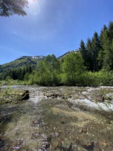
On December 18, the Washington Department of Ecology (Ecology) announced new rules designating portions of three waterways, the Cascade River, Napeequa River, and Skamania County’s Green River, as Outstanding Resource Waters (ORWs). The new designations are the end result of a multi-year effort by several organizations, including Cascade Forest Conservancy, to safeguard some of Washington’s most exceptional waters.
Under federal law, individual states are directed to designate waterways of exceptional ecological and recreational value as ORWs. These designations provide a high level of federal protection under the Clean Water Act of 1972, but until now, Washington had never used this tool.
The Green River’s new protections are well-deserved. The upper reaches of this waterway flow from the foothills of Mount St. Helens. This section of the river is beloved by recreationists of all kinds, including hikers, mountain bikers, backcountry horseback riders, hunters, anglers, botanizers, foragers, and many others. The river also has unique ecological significance due to its role as a gene bank for wild steelhead—an area set aside for wild fish populations to protect genetic diversity and ultimately the long-term health and survival of the species.
“Protecting Washington’s pristine waters benefits all Washingtonians and is critical for the state’s salmon and steelhead,” said Molly Whitney, Cascade Forest Conservancy’s Executive Director. The Tier III A classification assigned to the Green River means that new forms of pollution along the designated portions are prohibited.
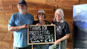
Securing these designations would not have been possible without the help of concerned citizens, including many CFC supporters! After attending an event supporting the new rule held at the beginning of September, Tara Easter submitted written comments and attended an in-person hearing in Kalama, WA.
“I felt it was important to show my support for these designations as a Washington resident concerned with the health and resilience of our freshwater ecosystems,” she explained.
The passion and advocacy of our community was a significant help in our efforts to see these new protections enacted. Thank you to everyone who submitted comments or otherwise supported this effort!
Thanks to the supporters who came out in support of Washington’s first ORW designations
In addition to added protections for the ecosystems and wildlife of the Green River, this designation is particularly helpful towards our long-term efforts to defend the surrounding area against the threat of mining. While these new protections do not explicitly prevent mining in this area, they will make it more difficult and costly to develop a mine here. In this way, the designation of the Green River as an ORW directly compliments our ongoing work with the Green River Valley Alliance to secure permanent protections for the area through a legislative mineral withdrawal.
We are thrilled Ecology has recognized the unique values of the waterways that have become Washington’s first ORWs—especially of the Green. Keep an eye out for an in-person celebration of these designations in the new year as we mark a successful end of this multi-year, collaborative effort.
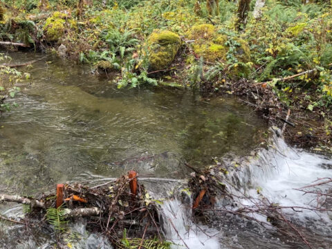
After building instream structures in a dry creek bed this past summer, we headed back to Stump Creek in early November to see how the structures faired following the first bout of rain. As we headed down to the project site, we saw new channels that had formed, sediment had built up behind structures, and huge, deep pools had appeared. And in those huge pools – we saw huge coho salmon!
Tributaries of large rivers provide off-channel spawning habitat that is critical for the end of an adult salmon’s life and their juvenile offspring. Stump Creek is a tributary that flows into the South Fork Toutle River, then into the Toutle River, Cowlitz River, Columbia River, and ultimately to the Pacific Ocean. That’s roughly 100 miles of waterways that these adult salmon travel to the ocean to grow big and then back to freshwater to spawn. Their journey from Pacific Ocean to Stump Creek is completely undammed, which is a rarity for anadromous fish to encounter. We are luckily seeing a movement to get more dams removed in the Pacific Northwest to restore access to more historical spawning grounds.
The fish that make it to Stump Creek in the winter are met with a flowing stream and many reaches with spawning gravel. Once the fry hatch, they have plenty of water to swim and forage. By the time August roles around, the creek begins to dry up, leaving juvenile salmon stranded in small pools. During the past two summers we have been at Stump Creek, we have found many dried out stream reaches that have piles of desiccated salmon fry. For this reason and it’s degraded state caused by anthropogenic and natural disturbances, Stump Creek has been a high priority for CFC and project partner, Lower Columbia Fish Enhancement Group.
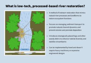
A LOW-TECH, PROCESS-BASED APPROACH
Following the promising results from last year’s successful Pilot Phase CFC staff and volunteers spent three weekends in August and September working to complete Phase 1 of our restoration plan for Stump Creek.
During the Pilot Phase and Phase 1, we worked to restore and improve this important fish habitat using a low-tech, process-based approach.
COMPLETING PHASE 1
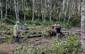
Given the impacts we observed from the Pilot Phase, we were excited to add more wood to the stream. Over the course of three weekends, we installed a total of 32 structures along 1500 feet upstream of the Pilot Phase.
The first group of volunteers and staff arrived at the site in August and found a situation similar to what we had encountered the year before; dried-out stream reaches and fish stranded in tiny pools. We didn’t assume our first ten structures would completely fix Stump Creek, but the sight we encountered reiterated the huge need for more woody debris to help enhance and restore the system.
Our first team of volunteers worked hard in sweltering heat under hazy skies to construct the first 12 structures upstream from the Pilot Phase. These structure types ranged from:
beaver dam analogs – wood structures that most closely resemble a beaver dam, used on smaller, less powerful side channels
channel process structures – larger wood structures made from numerous alder logs and slash that were built up on one side of the bank to promote the movement of water to the opposite side of the structure
channel spanning structures – larger beaver-esque structures made of numerous alder logs and slash that hold back sediment and create large pools
habitat cover structures – tops of the alder trees that are placed over the stream to provide cover for our aquatic friends
The second weekend of work brought nicer weather and an even bigger group of volunteers! They managed to finish up the rest of the structures for a total of 32 structures. A few weekends later, a handful of volunteers and I went to put some finishing touches on the structures, set up wildlife cameras so we could watch the system change through time, and create a few extra habitat cover structures to try and help the dozens of fish that still remained in the tiny pools.
ENCOURAGING EARLY RESULTS
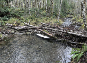
A final staff trip was conducted on November 10th. It had been raining for weeks, so it was time to see how the structures were holding up. We started by checking out the structures constructed during the 2022 Pilot Phase. As we’d observed earlier in the year, water in the Pilot Phase area was spreading all over the landscape and creating new channels.
We headed west toward the Phase 1 structures. We first passed several of our larger channel process and channel-spanning structures. Not only were they all in place, they were directing water in the direction and manner we had designed them to when we planned the project!
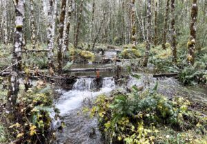
As we went further upstream, we came to our BDA section that we created on a side channel of Stump Creek. Our four BDAs that were working exactly as designed. We had created four cascading pools and spread the water outside of the previously confined channel. It was the perfect habitat for salmon!
So perfect in fact, that it was where we saw the first adult coho salmon of the day! We ended up seeing numerous other adult coho salmon utilizing the habitat enhancements our structures created. Some of them were swimming in the pools formed by the BDAs, others were preparing their redds (gravel bed to lay eggs) for spawning, and another was headed up stream to find find a location to spawn.
It was an incredibly rewarding sight. The lives of these coho would end here in Stump Creek, but their eggs are currently being incubated and will hatch in the next month or so. Once they do, our instream structures will be there to provide habitat for the new juvenile coho until they swim to the ocean.
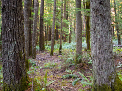
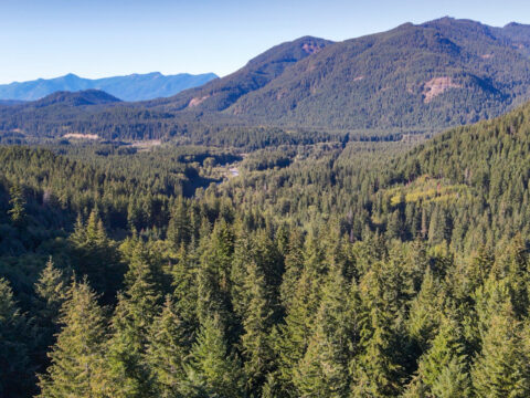
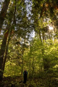
The Little White Salmon watershed is a 86,000-acre area spanning the transition zone between the wetter west-side forests and drier east-side forests of Washington’s southern Cascades, 80% of which is within the Gifford Pinchot National Forest. Due to its location, the watershed contains a unique mix of forest types and a high level of biodiversity, but it’s also at risk from significant climate impacts.
It’s no surprise then that this watershed is at the center of conversations about how to best manage forests on the verge of change, or that there are differing opinions about what that means.
The U.S. Forest Service is contemplating treating a huge area within the watershed through a combination of commercial and non-commercial thinning. In a break from other recent timber sales in the forest, the initial scoping plans for the Little White Salmon timber sale include considerations to thin thousands of acres of mature and transitional forests, although planners have publicly acknowledged they expect the amount to decrease as the agency moves closer to creating a final version of its plan.
The agency is proposing thinning in mature forests to mitigate the increasing impacts from drought, insects, disease, and wildfire that this area is likely to experience.
Generally, Cascade Forest Conservancy doesn’t support plans that involve thinning activities in mature forests, as these are areas of high ecological and carbon storage value and it is unclear whether the potential benefits of thinning would offset the more immediate negative impacts of harvest.
However, we understand the situation is nuanced and there is a lot of complexity and uncertainty – particularly in this transitional watershed. Because of this, we have been visiting these stands and collecting data to help inform our efforts ensuring that forests and wildlife remain resilient to the threats of climate change.
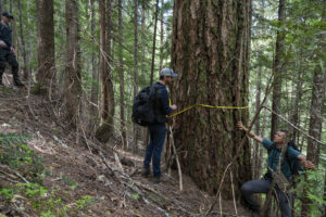
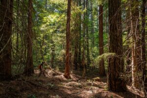
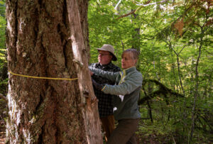
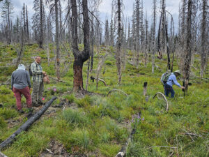
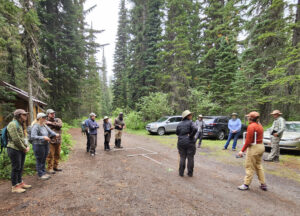
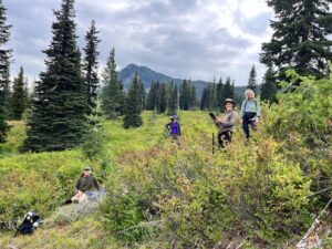
On the last weekend of September, CFC staff and volunteers ventured off the beaten path in the Little White Salmon watershed to collect on-the-ground information.
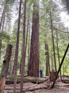
We targeted some of the older stands (those between 120 and 300 years of age) for our data collection efforts to see for ourselves if the on-the-ground conditions matched up with age estimates and to gain information about forest conditions that spatial analysis cannot provide.
Teams of volunteers spread out and conducted surveys collecting information about tree species, tree densities, tree diameters, the presence and amount of large downed wood, and species diversity in the understory in 30-foot radius circles.
Each team worked hard to collect as many plots as possible and everyone gained some skills in estimating tree sizes and types by the end of the trip. Each team found well-functioning mature forest stands and a number of large trees in the survey area, with the biggest coming in at 57 inches in diameter.
In the coming weeks and months we will be discussing this timber harvest proposal with the South Gifford Pinchot Collaborative and the Forest Service and working to make sure that critical habitats are protected and that management plans are well-tuned to ecosystem resilience.
Thanks to all the volunteers who gave their time and energy to this project!
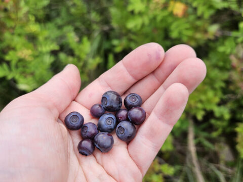
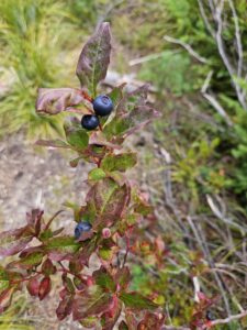
I recently joined Cascade Forest Conservancy staff and volunteers in the field to survey big huckleberry fields in the Gifford Pinchot National Forest. Huckleberries are an important (and delicious!) source of nourishment for many species in the Pacific Northwest–including us humans. However, huckleberry production levels today are well below historic numbers.
Like most fruit-producing species, big huckleberry (Vaccinium membranaceum) fruit production is heavily influenced by the amount of sun a plant receives. Because the plant’s foliage is naturally resilient to low-intensity fires, Indigenous peoples in the Pacific Northwest set fires to clear and maintain huckleberry fields and maximize fruit production for centuries until their lands were taken and the US government adopted a policy of aggressive fire suppression.
The fire suppression policies that began more than a century ago have allowed conifers and other species to encroach on what were once carefully maintained and incredibly productive huckleberry fields that had sustained people and animals for generations. But in the past couple of decades, there has been a growing interest in restoring some historic huckleberry picking sites–including areas in Washington’s Gifford Pinchot National Forest.
Between 2010 and 2016, the U.S. Forest Service worked with the Cowlitz Indian Tribe and other stakeholders to perform thinning activities designed to benefit huckleberries and CFC was tasked with monitoring the forest stands post-harvest to assess how effective these efforts have been in enhancing huckleberry.
To execute these surveys, CFC has enlisted volunteers since 2017 to collect data throughout the previously harvested forest stands to collect hundreds of data points. This year’s trip was a follow-up to an initial survey conducted at the Sawtooth Berry Fields in 2017 and 2018. The berry fields are just north of Indian Heaven Wilderness and are regarded as one of the most productive berry fields in the Pacific Northwest. To conduct the surveys, we started with a map of plot locations and a kit that included an iPad for collecting data, a rope to ‘draw’ the plot, a stake to mark the plot, a densitometer (a tool to measure canopy density), and a few other nifty gadgets.
After an overview of the project and a tutorial on how to do the surveys, we had to figure out who should do what job. I felt prepared, but also stressed since I was leading the group. The past few days I had practiced doing each job, but now it was time to put it into action. Learning how to use a compass was, interestingly enough, no easy feat. Still, I felt nervous because I wanted to ensure our group collected all the data we needed, without becoming a ‘dictator of the plot,’ so to speak.
Soon, we fell into a routine where we each had our designated jobs and could rely on each other. If I was tired, someone would trade jobs with me so I could rest, and vice versa. One of my favorite areas we visited was a mossy grove, with golden sunlight streaming through. If only I could catch that sunlight, bottle it up, and create… gold. No, not even gold shines like that. Purple lupine leaves gathered water and sparkled like otherworldly jewels. The leaves of one tree seemed to reflect the sunlight and created jade and emerald-like leaves. I smiled, realizing with these jewels, I must be one of the richest people in the world.
Our next plot had the most delicious and red wild strawberries anyone could imagine. I couldn’t resist picking a few. Gabe asked if I got the densitometer reading, but he mixed up the word, calling it an appendectomer. I smile and take the reading as Gabe asks what it’s called again. “A densitometer,” I say, pronouncing the word.
We all offered up a collective sigh of relief as we finished what would be the last plot. Tired but satisfied with our work, we walked along the road, stopping to eat huckleberries on the way. A truck passed us with kids riding in the back who smiled and waved at me. I waved back, wondering why they thought they knew me. Well, maybe they don’t have to know how to wave. Maybe it’s enough we’re all out here to search for huckleberries.
The next day was damp and misty, giving the forest an almost ethereal mystery. We trekked through a new project site, and by late afternoon, we finished our final plots. After two days of conducting huckleberry surveys, we could find north at the drop of a hat, establish the plot with the rope in no time, and whip out the iPad to collect data like no one’s business. We were a certified team and an efficient one at that. The feeling of accomplishment was palpable, and I think we all could agree that it was a successful two days (and one night) in the field! Our great volunteers and staff make this kind of great work possible, and it made me feel so proud to be able to become a part of the cause.
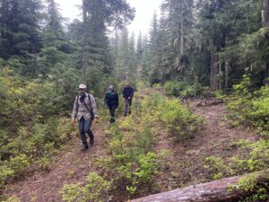
Last month, Cascade Forest Conservancy staff and volunteers ventured out to the forests and meadows between the Dark Divide and Spencer Ridge roadless areas to capture on-the-ground information for a potential future protected area. This part of the forest, which we refer to as the Clear Creek area, has been part of internal discussions at CFC for the last several months as we have been refining conservation recommendations that will be included in our soon-to-be-published second-edition Climate Resilience Guidebook.
While out in the field, participants ground-truthed old-growth maps to ensure we are protecting these rare habitats and surveyed roads that may be candidates for decommissioning. In addition to finding swaths of large Douglas-firs on the hillsides and groves of giants standing next to wet meadows, we toured miles of the forest road system to collect information about vegetative regrowth, culvert function, and general observations of use and disrepair.
Our Guidebook will examine the impacts that climate change is expected to have on southwest Washington’s ecosystems and outline recommendations to build resilience and increase carbon storage. We identified the Clear Creek area as a priority area for protection for a few reasons.
A LARGE ROADLESS REFUGE
First, because of its location between two roadless areas, protecting this area represents an opportunity to create a large, connected roadless area that can serve as high-quality, connected habitat for wildlife. It is already an area with relatively few roads, and most that do exist here are maintenance level 1 roads, meaning they are likely remnant roads from the timber heyday and not open for public use. These remain in the system in case they are needed for future timber harvests. There are also a handful of maintenance level 2 roads. These are backcountry roads, which in some cases are well used and appreciated and in other cases are under-maintained and already starting on a process of natural recovery where trees and other vegetation are reclaiming their foothold. These roads can be good candidates for closure and if old culverts remain along the route, they are good target roads for more thorough decommissioning where natural water flows are re-established and the area is set back on a trajectory toward wild-ness.
Over the next few years, we plan to work with volunteers to better understand which roads are suitable candidates for closure or decommissioning and to work with agency staff to advance these efforts. As a large roadless area with beautiful meadows and ancient old-growth forests, we will also explore opportunities to increase backcountry recreation opportunities like hiking and backpacking. There are many defunct roads which could be good candidates for a road-to-trail conversion.
A DENSITY OF OLD-GROWTH
Another reason this area became a top contender for protection is the presence of large tracts of intact old-growth and mature forests that exist here. Old-growth forests are a relatively rare ecosystem in the region, so we work diligently to ensure that all old-growth is retained and mature forests are protected to serve as our future old-growth.
In the coming months, we will be publishing the Climate Guidebook with pinpointed strategies for improving the health and resilience of the landscapes of the southern Washington Cascades. Stay tuned!