[vc_row row_type=”row” use_row_as_full_screen_section=”no” type=”full_width” angled_section=”no” text_align=”left” background_image_as_pattern=”without_pattern” css_animation=””][vc_column width=”1/12″][/vc_column][vc_column width=”5/6″][vc_empty_space][vc_column_text]
Mining Again Threatens Mount St Helens Area Wild Fish and Habitat
By Matt Little, Cascade Forest Conservancy
Originally published in The Osprey Newsletter, May 2018
Download a PDF copy of the article by clicking HERE.

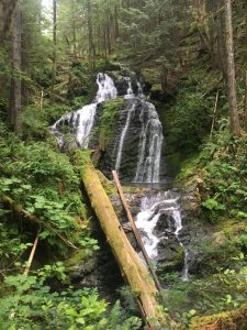
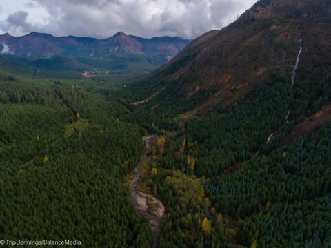
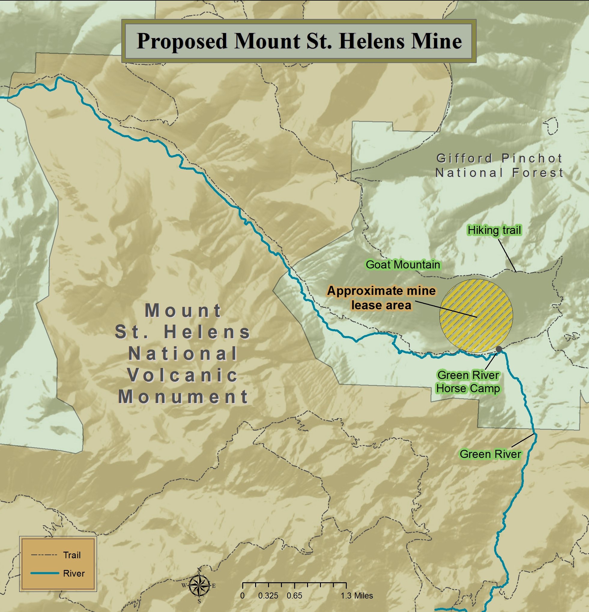
Just north of Mount St. Helens lies the beautiful and pristine Green River valley, which is a treasured wild steelhead refuge and a destination for backcountry recreationists. It is also the site of a proposed gold and copper mine, and a battle that has been raging for over a decade.
The headwaters of the Green River lie in a steep and verdant valley in the remote northeastern portion of the Mount St. Helens National Volcanic Monument and contain one of the world’s unique ecosystems. Following Mount St. Helens’ 1980 eruption, this valley had areas that were scorched by the blast and other areas that were sheltered and where old growth forests survived the volcanic catalysm. This resulting mix of native flora and fauna at various levels of succession created a mosaic of diversity that today supports a diversity species from wildflowers to herds of elk, and enjoyed by recreationists from bird-watchers to anglers.
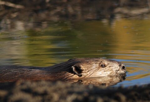
The Green River flows in and out of the Monument’s borders, snaking its way west through the glacial-carved landscape of Green River valley. Further downstream, it flows into the famous Toutle/Cowlitz River system. From the Cowlitz Trout Hatchery and North Toutle Hatchery down to the Columbia River, this popular stretch provides anglers with abundant opportunities to catch salmon and steelhead. What many anglers don’t know, however, is that above this system flow waters so clean, clear, and productive for wild steelhead that the Washington Department of Fish and Wildlife designated it in 2014 as one of the state’s first “Wild Stock Gene Banks”, to protect the integrity of the genetic stock. The Lower Columbia Fish Recovery Board also identified the Green and North Fork Toutle Rivers as “Primary” waters — their highest designation — for the recovery of fall Chinook and coho salmon, and winter steelhead, in the lower Columbia River Basin. The clean water and habitat values of the Green River, and proximity to the scenic Mount St. Helens National Volcanic Monument, also led the US Forest Service to determine that the Green River is eligible for Wild and Scenic River designation.
The valley is a treasure trove for other backcountry pursuits as well. It is a valuable wildlife corridor for the seasonal migration of a large elk herd, long recognized by the state wildlife agency for its habitat values. It also contains the Norway Pass special permit area for elk, highly coveted by hunters. Outdoor enthusiasts often start their adventures at the Green River Horse Camp to hike, bike, or ride horses along the 22-mile Goat Mountain and Green River loop trails through blast zone and old growth forests, and past beautiful alpine lakes and mountain views.
Enter Ascot Resources Ltd. This Canadian-based mining company has plans to explore for an industrial-scale mine in this valley. However, they are not the first prospectors to the area. In 1891, two German immigrant farmers were on a fishing and hunting expedition and found evidence of precious metals. This set off a mining rush in the area and led to the establishment of the Green River mining district in 1892 (later named the St. Helens mining district) to manage the numerous claims. However, these mining ventures proved to be unprofitable, and by 1926, the three companies that had explored the Green River valley deposits (called Mount Margaret) had failed. The gold rush had ended.
The latest search for industrial-scale gold and copper started in 1969 when Duval Corporation acquired the Mount Margaret mining rights and drilled 150 core samples in the 1970s. Following the eruption of Mount St. Helens in 1980, Duval sold their claims to the Trust for Public Land. For over a decade, there was little interest in mining in the Green River valley until 1993, when Vanderbilt Gold Corp. applied for a mining permit in the area. The Bureau of Land Management (BLM) concluded that mineral concentrations in the area were too low to be profitable and denied the permit.
In 2004, Idaho General Mines, Inc. (later known as General Moly Inc.) acquired a 50% interest in the Mount Margaret deposit and applied for a hardrock mining lease. The local conservation group, Cascade Forest Conservancy (CFC), then called the Gifford Pinchot Task Force, responded by rallying support from the community. The cities of Longview, Kelso, and Castle Rock, which depended on the Green and Toutle Rivers for their drinking water supplies, all passed resolutions against the mine proposal. During the public comment period for the mining permit’s Environmental Assessment, over 33,000 people expressed their concerns about the proposal. In 2008, the BLM denied the lease.
In March of 2010, the Canadian-based mining company, Ascot Resources Ltd., purchased the mining rights from General Moly Inc. In a very short time, and without an environmental assessment, the Forest Service approved Ascot’s drilling plan. By August the company had drills in the ground taking core samples. CFC requested an injunction and stopped the drilling by the summer of 2011. Ascot Resources quickly submitted a new permit in late 2011, which this time the Forest Service and BLM approved. However, CFC prevailed in 2014 when a federal court invalidated the permits and the parties withdrew their appeals.
Not to be discouraged, Ascot started writing another application in 2015. In January of this year, the Forest Service yet again approved the permit and passed it along to BLM for their review and concurrence. It is likely the agency will concur with the decision very soon, making it final.
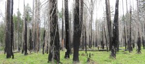
An industrial-sized mine in the Green River valley would be catastrophic for fish, wildlife, and recreation. These types of mines often require huge open pits to process the amount of rock and minerals necessary to be profitable. They also require massive containment ponds held back by earthen dams to hold the toxic materials and heavy metals left in the tailings sludge after mining, including copper, lead, cyanide, cadmium, mercury, and arsenic. These “ponds”, are notorious for leaking or failing over time. If one of these is built in the steep Green River valley, which is in a seismically active area in the shadow of an active volcano, the earthen dams are almost guaranteed to fail. In 2014 a tailings dam at British Columbia’s Mount Polley Mine failed, destroying whole salmon rivers with toxic sludge. Nobody wants this to happen to the Green River.
A leak containing even the smallest amount of dissolved copper can disrupt a salmonid’s olfactory senses, and at 2.3–3.0 mg/L it can be lethal. Heavy metals not only impact fish, but they build up in the living tissue of organisms as they travel up the food chain and affect just about every living creature in the ecosystem, including humans. Mercury is notorious for this and is a potent neurotoxin, greatly affecting the nervous system.
Exploratory drilling alone can have significant impacts to fish and recreation along the Green River. Ascot Resources has plans to perform test drilling at 23 drill pads that will create 63 boreholes. The drills use chemical additives during the drilling process and a bentonite-based grout afterwards that can have impacts to groundwater and surface waters. The closest drilling sites are just 150 feet from Green River tributaries and others are approximately 400 feet from the Green River itself. Also, trees will be removed and formerly closed roads will be reconstructed, which will further impact the streams and fish.
Drilling, truck traffic, and other activities will create 24/7 noise throughout the summer into mid-fall, the same time of year that people visit this area for backcountry recreation and solitude. Bow season for elk and deer begins in September and the proposed mining site is the where most backcountry trips begin, since it is the end of the road and it is where the horse camp and trails begin. The fishing experience would certainly be disrupted, as well as the direct impacts to other fish and wildlife from the project itself.
A large coalition of recreation and conservation groups have partnered with the Cascade Forest Conservancy to oppose this mine. The Clark Skamania Flyfishers (CSF), established in 1975, is one of the most vocal opponents of the mine because of potential impacts to the local fishery. In a powerful video about the mine on Cascade Forest Conservancy’s website, CSF’s Steve Jones is documented fly fishing the Green River and talking about the inevitable impacts that mining will have on the 14-16 pound steelhead he loves. Others opposed to the mine include the Cowlitz Indian Tribe, the original owners and managers of this land, and even the Portland-based rock band Modest Mouse, who currently has an ad out against the mine on their main webpage.
All these calls to action have been heard by decision makers, including leaders in Congress. Washington’s Democratic Senator Maria Cantwell is an important ally for mine opponents, especially through her role as Ranking Member on the Senate Energy and Natural Resources Committee. In a 2016 Committee hearing on the Forest Service budget, Senator Cantwell grilled the former Chief of the Forest Service, Thomas Tidwell, on his agency’s insufficient review of this mine and the impacts it will have on the valley.
Ironically, all of the 900 acres currently under consideration for exploratory drilling were once owned by the conservation-focused Trust for Public Land (TPL), who had purchased it from Duval. In 1986, following the creation of the Mount St. Helens National Volcanic Monument, TPL donated and sold their land and the mining rights to the Forest Service. During the land transfer, TPL wrote that they expected that the mineral rights “would be removed from entry under the General Mining Laws.” Fortunately, some of these lands were also purchased using money from the Land and Water Conservation Fund (LWCF).
The Land and Water Conservation Fund Act was established by Congress in 1964 to use money generated from off shore oil and gas leases to acquire lands for conservation and recreation purposes. Since its inception, LWCF has protected over five million acres of conservation and recreation lands across the country. A mine established on these lands would be devastating not only to the Green River valley, but for public lands everywhere.
So what’s next? The Cascade Forest Conservancy and its coalition partners will continue to fight drilling in the Green River valley, including through more litigation if necessary. The coalition hopes for a permanent end to mining in this valley and is asking our leaders in Congress to lead a solution that will preserve the area’s exceptional fish populations, wildlife habitat, and backcountry recreation opportunities. The Land and Water Conservation Fund has strong bipartisan support, and any solution should also preserve the integrity of this law and the public lands it has protected.
The Green River valley is unique, and the fish, wildlife, and communities that depend on it for their livelihoods deserve our long-term support and protection. To learn more about this proposal and see a video of this beautiful landscape, go to https://cascadeforest.org/our-work/mining/. Also, please consider joining the Cascade Forest Conservancy as we work toward the long-term preservation of this treasured watershed.[/vc_column_text][/vc_column][vc_column width=”1/12″][/vc_column][/vc_row]


 extended the process through March 23 through “continuing resolutions” which provide temporary funding for federal agencies and avoid a government shutdown while Congress works through the appropriations process. This spending bill is large because it is an omnibus bill that combines the twelve funding areas.
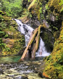
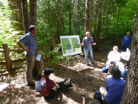
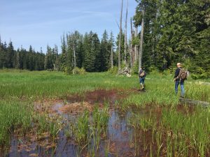
 During the warmer months our meetings involve field trips where we can see proposed sale units or projects after they are completed. Seeing how projects look on the ground inspires robust conversations about topics such as riparian habitat, harvest practices, and roads. Last year, the SGPC went on a trip to a temporary road that had been used in a timber sale and obliterated. Seeing this former temporary road led to a discussion about the impacts of temporary roads that is ongoing. The Pinchot Partners visited units for the Iron Crystal timber sale and areas that would be part of huckleberry monitoring efforts. During the huckleberry trip, Pinchot Partners members were able to learn about our huckleberry monitoring process from CFC staff.
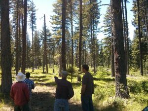
 Over the last year in the South Gifford Pinchot Collaborative we have worked on the Upper White Salmon timber sale, formed subcommittees to focus on important topics, and began discussing the Middle Wind timber sale. The Upper White Salmon project was located in drier forest near Mt. Adams. A focus of the collaborative discussion in this project was the harvest prescription for mature forest units with large trees. After several meetings we were able to reach a compromise that considered wildlife habitat, the role of fire on the landscape, and the future climate change impacts. The Middle Wind project is located in a part of the GPNF that has many riparian areas and listed fish habitat. We would like to see this project implemented in a way that improves aquatic habitat and reduces road mileage in the watershed. We have also participated in subcommittee meetings to develop a Zones of Agreement document for the group focused on plantations. The intent of that document is to streamline discussion for topics we agree on, and to educate others about the SGPC.
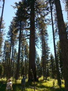 Finding common ground can sometimes be slow, challenging work. It often requires balancing environmental, economic, cultural, and recreational concerns and reconsidering what success means for each of us. Successful collaboration relies on a diverse group of stakeholders, representing a full spectrum of user groups, and bedrock environmental laws. Attempts to weaken environmental laws by Congress present a direct threat to the progress collaboratives have made toward rebuilding trust and developing projects that benefit forests and communities. We are encouraged by the progress these organizations have made since their formation, and we look forward to working on future projects together.

 Northwest Forest Plan
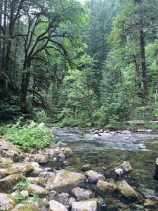 Mature forests, well on their way to developing old-growth characteristics, are at-risk in controversial clearcutting projects. Forests that are 80 years or older are often already developing the diversity needed to be valuable habitat and climate refugia. Logging these areas, if done at all, should focus on the development of old-growth characteristics. Commercial logging should focus on thinning plantations to improve diversity, as plantations offer little value for either habitat or carbon storage. Management of forests should look beyond their financial value for timber production and also consider their immense value in mitigating the costly impacts of climate change.
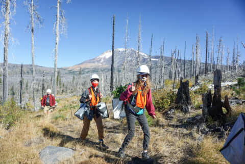